


Gathering crop data for NDVI mapping is no longer the sole province of mega farms with unimaginable budgets. Renting expensive satellite time or hiring a helicopter is a thing of the past.
All you need is a consumer drone—and the Parrot Sequoia Multispectral Sensor available from Drone Nerds. Sequoia can turn just about any consumer-targeted drone into an agricultural mapping drone. Gather data that, when analyzed, tells you how to adjust pesticides, herbicides, fertilizer and irrigation to maximize plant health and crop yield. Identify plant disease and treat it before it’s too late.
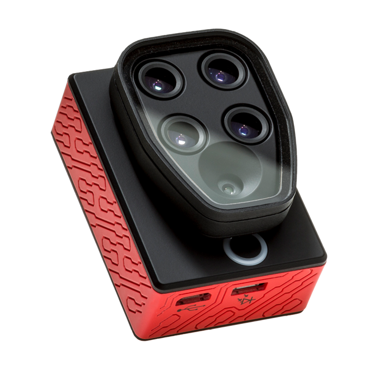
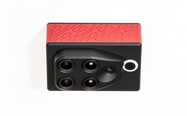
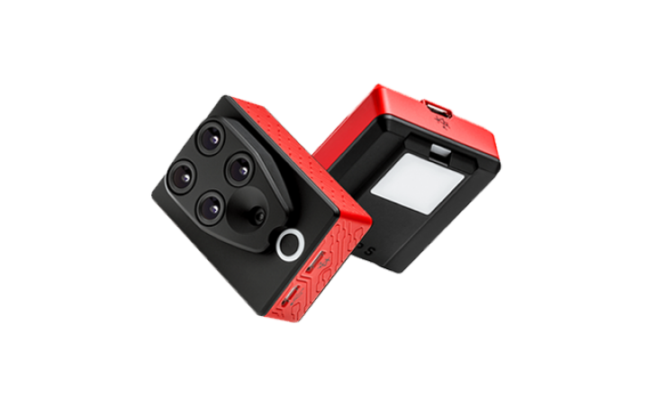
Sequoia is a precision instrument that belies its diminutive size and weight. The downward-facing Sequoia works in tandem with an included, upward-facing sunshine sensor. Together they weigh less than 4 ounces. The Sequoia itself is less than 2½ inches long; the sunshine sensor is even smaller.
Parrot Sequoia Multispectral Sensor features:
- Four cameras for capturing images of four bands: green, red, red edge and near infrared
- RGB camera for recording 14MP images of crops
- GPS and IMU for precise positioning and location of images
- Sunshine sensor for automatic adjustment of readings to ambient light
- 64GB built-in memory for recording data
- Slot for optional SD card to add memory and ease data transfer
- Accessibility to data by WiFi or USB port
- Geotagging of data and images
- Compatibility with multiple analysis services
- Adaptability for mounting to a wide range of multi-rotor or fixed wing drones
How Sequoia Works
Sequoia is not a single sensor, but a tiny, highly capable system of cameras and electronics. They work seamlessly to gather images and measure the light coming off crops and the fields in which they are planted. That data, which is geotagged for precisely locating where images and readings were taken, is analyzed for a detailed picture of crop health. It is basically the same process that satellites have used for years in doing NDVI measurements.
Sequoia attaches to the underside of your drone. It has four cameras that separately capture four bands of light, including two infrared bands invisible to the human eye:
- Green (550nm BP 40nm)
- Red (660nm BP 40nm)
- Red Edge (735nm BP 10nm)
- Near infrared (790nm BP 40nm)
Separate readings of the four bands of light produce analysis that is more detailed than and superior to data gathered by a single multi-band sensor. Sequoia does more than capture these light readings; it also adjusts for speed and height of the aircraft, and for sunlight at the time the readings are taken. So even if the day goes from sunny to partly cloudy or completely overcast, your readings will continue to be accurate. The sunshine sensor, which is included in your purchase, attaches to the top of your drone.
In addition, the Sequoia has an RGB camera that’s useful for scouting field and crop conditions. It can snap up to one full-color image a second; it points downward, along with the other camera lenses.
Because all images taken by Sequoia are geotagged, you’ll know the exact location of the field or portion of a field in each image and in each piece of data. That means you can give your drone coordinates and it will go right back there, where you can use Sequoia’s RGB camera to scout the area of concern.
Sequoia Enables Informed Decision-making
A farmer with a detailed crop map no longer has to make decisions field-by-field. Decisions on applying pesticides, fungicides, fertilizers and even water can be made on precisely defined parts of a field. This micro-plot management saves time and money by allowing a farmer to take action only where it is needed.
Taking prompt action can save crops, or even plants. Scientists have documented the saving of entire orchards by identifying and promptly attacking diseases after analyzing crop-mapping data.
Crop mapping and analysis of agronomic indices also play an important economic role by helping to forecast yield.
Plentiful memory
The Sequoia has 64GB of internal memory. The amount of data and number of flights it will record vary by aircraft, speed and altitude, but that’s likely enough for 8-10 flights.
A slot allows you to add memory with an optional SD card. That eases data transfer and allows you to record data from a single flight, then access or upload it quickly.
Data recorded on the internal memory can be accessed through built-in WiFI on each Sequoia or through its USB port.


- Identify the needs of your plants
- Made for all drones
- Easy to use and integrate
- Multispectral sensor
What’s in the box? Multispectral sensor, sunshine sensor, micro USBa-micro USBb cable, micro USB-USB cable, protection lens, microfiber cloth, 3 sunshine sensor mounts, 32GB SD card, user guide, quickstart guide.
Can the Parrot Sequoia be used with any drone? Yes, pretty much so. The drone being used must be capable of carrying it so that the Sequoia can be aimed at the ground with unobstructed view, and must be able to securely carry the sunshine sensor on top.
How much does Sequoia weigh? Total weight is a mere 3.7 ounces: Sequoia itself weighs 2.5 ounces, and the sunshine sensor weighs 1.5 ounces.
How big are the two units? They’re surprisingly small for such sophisticated instruments. Sequoia: 2.3 x 1.6 x 1.1 inches; sunshine sensor: 1.8 x1.5 x 0.7 inches.
How does Sequoia mount? It attaches to the gimbal on your drone.
Which analytical programs are compatible with Sequoia? You can have your data interpreted through Pix4Dmapper Pro, Airinov or MicaSense.
Must I use a fee-charging service to obtain analytics? The Sequoia’s software also will analyze data, although paid services provide much more detail.
How is the collected data accessed? You can tap the data either by WiFi or USB.
Does the Sequoia have built-in storage? Yes: 64GB.
How much data can I store on the 64GB? That may vary by length of flight but generally speaking, about 8-10 flights’ worth.
What is the purpose of the SD card slot? You can add additional memory and use the card for easier data transfer.
Is setup required? Minimal setup with the included software is necessary. You’ll also have to perform a handheld compass configuration because of the onboard IMU; it takes less than a minute.
How is setup achieved? Use a computer, smartphone or tablet to run the software and synch with your drone.
Do I have to set up the program before each use? No. Once you set up the device, that information is stored in the memory.
How do I know where the portion of the field showing on data and in images is in the real world? All images and data are geotagged for precise locating. Given those coordinates, the drone can take Sequoia right back to the area you want to inspect more closely. You can use Sequoia’s RGB camera to do this scouting.
Can I buy a drone that has the Sequoia already mounted and set up? The Parrot Disco-Pro AG is a highly efficient fixed-wing drone available from Drone Nerds. It’s designed with mounting points for the Sequoia’s proper aim and protection, and for maximum performance of the Sequoia from flight planning to data gathering, transfer and analysis.
- 1 Multispectral sensor
- 1 Sunshine sensor
- 1 Micro USBa-micro USBb cable to connect the two sensors
- 1 Micro USBb-USB cable to connect the multispectral sensor to the drone
- 1 Protection lens
- 1 Microfibre cloth
- 3 Sunshine sensor mounts
- 1 32 GB SD card
- 1 User guide
- 1 Quickstart guide
