

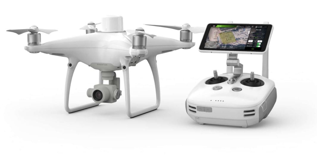


DJI Phantom 4 RTK + D-RTK 2 Mobile Station Combo (Shield Basic)
DRONE NERDS RECOMMENDED ACCESSORIES
Click here to read more about the DJI Phantom 4 Enterprise Series
How accurate do aerial maps need to be? When it’s business, when it’s construction, when it’s an inspection run, very accurate—centimeter-level accurate. That’s what the DJI Phantom 4 RTK and D-RTK mobile station combo delivers.
Now ask yourself how valuable your company’s time is. By offering the DJI Phantom 4 RTK and D-RTK combination, Drone Nerds demonstrates that it understands not only your needs for accuracy, but also your need to follow schedules, meet deadlines and control costs.
Aerial surveying and mapmaking with the Phantom 4 RTK simplify your workflow by requiring fewer ground control points, saving time. The Phantom 4 RTK delivers centimeter-accurate positioning data that produces maps built on improved absolute accuracy—without higher costs.
Phantom 4 RTK + D-RTK Mobile Station features:
- Ultra-high-resolution 4K camera
- Camera lenses calibrated for radial and tangential lens distortions
- 1-inch, 20MP CMOS sensor
- 4.3-mile range
- Adjustments for overlap rate, altitude, speed and camera parameters
- GPS accuracy, plus GNSS redundant sensor for poor-signal areas
- Mechanical shutter to eliminate rolling distortion
- Dual planning modes
- Direct loading of KML area files for in-office flight planning
- Strong-wind alarm
- Consistent exposure across all photos
Precisely Accurate Positioning Modules
DJI integrated a new RTK module into the Phantom 4 RTK for centimeter-level positioning data. The result is improved absolute accuracy on metadata. A redundant GNSS module sits just below the RTK receiver, so even in areas where signals are notoriously weak, such as urban canyons of concrete and steel, flight stability is maintained.
The GS RTK program augments flight planning for both mapping and inspection runs. The pilot can adjust settings, including overlap rate, altitude, speed, and camera parameters. The Phantom 4 RTK will be set up precisely for the work you’re performing on your jobsite.
Continual Alignment Through TimeSync
TimeSync, which is built into the operating system, contributes to improved accuracy by continually aligning the flight controller, camera and RTK module. Using the most accurate metadata, TimeSync fixes positioning data to the center of the 1-inch, 20MP CMOS sensor. The image employs optimization of photogrammetric methods to achieve centimeter-level positioning.
Mobile Workstation
The inclusion in the combo of the D-RTK Mobile Work Station allows connection anywhere, in any workflow, and it provides information—including high wind alerts—that increases accuracy. The work station supplies the Phantom 4 RTK with real-time differential data. By connecting through a 4G dongle or WiFi hotspot, the work station facilitates continuous data flow using the NTRIP protocol, which provides security for data while aiding distribution to multiple users. Data gets to internal or external clients quickly and accurately.
Long Range
The Phantom 4 RTK has a range of 4.3 miles. OcuSync transmits live images in 720p over that entire range. More importantly, 4K video and 20MP still imagery are transmitted for recording over that entire range, sending data that is highly accurate. Stored data can be accessed for detailed analysis and decision-making by stakeholders. The Phantom 4 RTK’s long range greatly augments the aircraft’s wide-area mapmaking and inspection capabilities.
Coming: Compatibility with SDK
Under development by DJI is a Software Developer Kit that will allow greater customization.
Next Generation Mapping
DJI has rethought its drone technology from the ground-up, revolutionizing its systems to achieve a new standard for drone accuracy – offering Phantom 4 RTK customers centimeter-accurate data while requiring fewer ground control points.

Centimeter level positioning system
A new RTK module is integrated directly into the Phantom 4 RTK, providing realtime, centimeter-level positioning data for improved absolute accuracy on image metadata. Sitting just beneath the RTK receiver is a redundant GNSS module, installed to maintain flight stability in signal-poor regions such as dense cities. Combining both modules, the Phantom 4 RTK is able to optimize flight safety while ensuring the most precise data is captured for complex surveying, mapping and inspection workflows.
Fit the Phantom 4 RTK to any workflow, with the ability to connect this positioning system to the D-RTK 2 Mobile Station, NTRIP (Network Transport of RTCM via Internet Protocol) using a 4G dongle or WiFi hotspot, or store the satellite observation data to be used for Post Processed Kinematics (PPK).

Gather Accurate Data with TimeSync
To take full advantage of the Phantom 4 RTK’s positioning modules, the new TimeSync system was created to continually align the flight controller, camera and RTK module. Additionally, TimeSync ensures each photo uses the most accurate metadata and fixes the positioning data to the center of the CMOS – optimizing the results from photogrammetric methods and letting the image achieve centimeter-level positioning data.
Precise Imaging System
Capture the best image data with a 1-inch, 20 megapixel CMOS sensor. Mechanical shutter makes mapping missions or regular data capture seamless as the Phantom 4 RTK can move while taking pictures without the risk of rolling shutter blur. Due to the high resolution, the Phantom 4 RTK can achieve a Ground Sample Distance (GSD) of 2.74 cm at 100 meters flight altitude. To ensure each Phantom 4 RTK offers unparalleled accuracy, every single camera lens goes through a rigorous calibration process where radial and tangential lens distortions are measured. The distortion parameters gathered are saved into each image’s metadata, letting post-processing software adjust uniquely for every user.
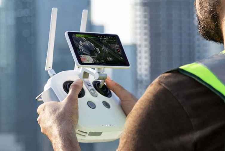
Purpose-Built Flight Planning Application
A new GS RTK app allows pilots to intelligently control their Phantom 4 RTK, with two planning modes – Photogrammetry and Waypoint Flight – alongside a more traditional flight mode. The planning modes let pilots select the drone’s flight path while adjusting overlap rate, altitude, speed, camera parameters and more, offering an automated mapping or inspection workflow.
The GS RTK app has been built with its users in mind and therefore has a range of features built for specific mapping or inspection workflows. The app has implemented direct loading of KML area files for in-office flight planning, a new shutter priori mode to keep exposure consistent across all photos and a strong wind alarm to warn pilots of adverse conditions.

Mobile SDK Supported
The Phantom 4 RTK is compatible with the DJI Mobile SDK, opening up its functions to automation and customization through a mobile device (coming soon).
OcuSync Transmission System
Enjoy stable and reliable HD image and video transmission at distances of up to 7 km, great for mapping larger sites. *Unobstructed, free of interference, when FCC compliant. Maximum flight range specification is a proxy for radio link strength and resilience. Always fly your drone within visual line of sight unless otherwise permitted.
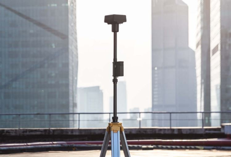
Seamless Compatibility with D-RTK 2 Mobile Station
Support your Phantom 4 RTK missions with the D-RTK 2 Mobile Station – providing real-time differential data to the drone and forming an accurate surveying solution. The Mobile Station’s rugged design and OcuSync 2transmission system ensures you can gain centimeter-level accurate data with your Phantom 4 RTK in any condition.
Start Mapping Today
With a built-in flight planning app (GS RTK) and an easy method to collect RTK data (RTK Network or D-RTK 2 Mobile Station), pilots have a full solution for any surveying, mapping or inspection workflow – right out of the box.


Click here to read more about the DJI Phantom 4 Enterprise Series
PRODUCT
1.How does the Phantom 4 RTK differ from previous Phantom Series products?
While previous Phantom series drones were built around professional photographers and hobbyists, the Phantom 4 RTK was designed for industrial users for high-precision mapping and other data acquisition missions. While the Phantom 4 RTK shares a similar camera and form size, it also adds a RTK positioning module, a new TimeSync system, a purpose-built mapping app and more.
2.What propellers does the Phantom 4 RTK use?
The Phantom 4 RTK uses the same 9450s Quick Release Propellers as the Phantom 4 Pro.
3.Can I fly the Phantom 4 RTK in other countries or regions?
No, the Phantom 4 RTK has specific versions for different countries and/or regions. Users can check the version code on the product packaging or through the GS RTK app (go to Aircraft Information -> Firmware).
CAMERA
1.What is difference between the Phantom 4 RTK's camera and the camera on the Phantom 4 Advanced/Pro?
While the Phantom 4 RTK and Phantom 4 Pro/Advanced share the same 1-inch, 20 megapixel CMOS sensor, the Phantom 4 RTK has improved the capabilities of the camera for mapping through a new lens distortion recording process. Each Phantom 4 RTK camera goes through a calibration process that measures the distortions of the lens, and records the corresponding OPEN-CV parameters. The camera allows users to output the original images without distortion correction as well as the OPEN-CV distortion parameters in the XMP file for post-processing
2.Can the ND filter of the Phantom 4 Pro be used on the Phantom 4 RTK?
Yes, the ND filters made for the Phantom 4 Pro can also be used for the Phantom 4 RTK.
3.Does the Phantom 4 RTK camera digital signal processor (DSP) support distortion correction?
No, you can enable the distortion correction in the camera but the images will be less precise compared to distortion elimination in post-processing software.
REMOTE CONTROLLER
1.What’s the different between the remote controller of the Phantom 4 RTK and that of the Phantom 4 Pro?
The Phantom 4 RTK's remote controller has multiple changes that add more versatility and features for industrial users. This includes a Micro-SD card slot, a built-in speaker and hot-swappable batteries. Additionally, users can use the remote controller to connect to the internet for Network RTK with a 4G Dongle. Lastly, the new GS RTK App is pre-installed in each remote controller, letting controller start data acquisition missions right out of the box.
2.Can you control the Phantom 4 RTK with the Phantom 4 Advanced/Pro controllers?
No, you cannot control the Phantom 4 RTK with a Phantom 4 Advanced or Pro controller.
3.How can I switch between FCC and CE modes?
FCC and CE mode switching is not available.
4.How do I bind my remote controller with the Phantom 4 RTK?
You can complete the linking through the GS RTK app. Refer to the User Manual for more details.
VIDEO TRANSMISSION
1.What is the video transmission distance of the Phantom 4 RTK?
The effective video transmission distance depends on your method of operation (such as the antenna position) and actual flight environment. In an open and unobscured environment, the maximum distance is 7 km when FCC compliant, and 4 km when CE compliant. (2.4GHz).
2.What should I do if the app sends me the following notification: "the remote controller signal is weak, please adjust the antenna"?
This means that improper antenna positioning is likely affecting the video transmission signal, and therefore the quality of the real-time view. You can try to adjust the antennas so the flat sides of the antenna point towards the Phantom 4 RTK.
3.Can I continue my automated mapping mission if the Phantom 4 RTK loses video transmission signal during its mission?
Yes, if the video transmission signal is lost, you can reconnect and continue the mapping mission.
BATTERY
1.Can I use my Phantom 4 Pro batteries with the Phantom 4 RTK and vice versa?
Yes, the Phantom 4 RTK and Pro batteries are cross compatibe and have the same capacity, meaning flight time won't be effected.
2.How long does it take to fully charge a Phantom 4 RTK battery?
It takes roughly 60 minutes to charge a Phantom 4 RTK battery fully.
3.How should I take care and store my batteries?
Keep the Phantom 4 RTK batteries in a dry place away from water. For long term storage, ensure the battery is charged to 50% or above and discharge every three months to maintain activity.
4.What does it mean when the battery icon turns yellow in the app?
This means the voltage of the battery cell is below 3.62V and should be charged soon.
5.Can I use Phantom 4 RTK batteries in low temperatures?
The battery capacity (and therefore flight time) will sharply decrease in low temperatures (< -10℃). It is recommended to heat the batteries to 20℃ before flight to limit this effect.
6.Why do batteries start to heat up after long term storage?
This is a normal phenomenon. When batteries have been stored for a long time with over 65% of the charge remaining, an automatic discharging procedure is activated to decrease battery level to 65%, during which the batteries will heat up.
POS RTK AND PHOTO POS
1.What options do I have to reference the positioning data from the Phantom 4 RTK?
1. Connect locally via OcuSync to your D-RTK 2 Mobile Station. (RTCM3.2)
2. Connect remotely via a 4G Dongle to a custom RTK network using a NTRIP account.(RTCM3.2)
3. Connect remotely via a WiFi hotspot to a custom RTK network using a NTRIP account. Not available in Europe.(RTCM3.0/RTCM3.1/RTCM3.2)
2.What positioning accuracy can the Phantom 4 RTK achieve?
The Phantom 4 RTK can achieve 1 cm+1 ppm (horizontal), 1.5 cm + 1 ppm (vertical) accurate data.
3.What is TimeSync and how does it ensure the positioning accuracy of each image taken on the Phantom 4 RTK?
TimeSync continually aligns the flight controller, camera and RTK module, then adjusts the positioning data to the center of the CMOS and records the data in EXIF and XMP format.
4.What are the differences between PPK and RTK mode? How to use them?
RTK and PPK are two different kinematics technologies that reference data in different ways. Although PPK generally has slightly higher positioning accuracy than RTK, both achieve centimeter-level precision. RTK is recommended for users flying in environments that allow for real-time connection via OcuSync or 4G and prefer convenience and efficiency. For users who have no demand on timeliness and/or need to operate in conditions without connectivity, PPK is a better option.
5.How do I find the XMP information of my Phantom 4 RTK photos?
Open the photo in text format and search "XMP" to find this information on each photo.
6.When I take a photo with the Phantom 4 RTK, where is the location metadata logging the position from?
Due to the new TimeSync system, each photo stores the position of the CMOS center in its metadata.
7.How can I get the compensation value between the antenna phase center and CMOS center?
For each photo, the compensation value between the RTK module's antenna phase center and the CMOS center in NED coordinate system is recorded in the timestamp.MRK file under a folder named “survey”.
SOFTWARE
1.How do I update the Phantom 4 RTK firmware?
The Phantom 4 RTK firmware upgrade process is similar to that of the Phantom 4 Pro. Using the DJI Assistant 2 software, you can update the remote controller and aircraft firmware seperately.
You can also update the drone and remote controller simultaneously through the GS RTK app. First yoyu connect the remote controller to the aircraft with OTG and USB cables, then follow the procedures explained in the remote contoller's GSRTK app.
2.In what situations are the left/right TOF and infrared sensors active?
Currently the left/right TOF and infrared sensors are not active, so please fly with caution.
3.What apps have mapping or inspection function?
Users can use the pre-installed GS RTK app for mapping or inspection missions. Additionally, users can install apps built on DJI's Mobile SDK.
4.Does the Phantom 4 RTK's return to home logic differ from that of the Phantom 4 Pro?
No.The RTH logics in both aircrafts are almost the same.
5.Are there any limitations to the Phantom 4 RTK's waypoints?
Yes, the distance between any two waypoints can not be above 2 km, the total number of waypoints cannot surpass 99 and the entire length of the flight path cannot exceed 15 km.
6.Can I set waypoints by entering longtitude and latitude values when using Waypoint mode?
No.
7.When importing KML area files with the GS RTK app, what is the maxmum number of boundary points that I can set?
Currently the GS RTK app supports up to 99 boundary points through KML files.
MAPPING
1.What formats of differential data does the Phantom 4 RTK support?
Currently the Phantom 4 RTK supports RTCM 3.0 data, RTCM 3.1 data, MSM4 and MSM5 data under RTCM3.2.
2.Are the coordinates measured by the Phantom 4 RTK relative coordinates or absolute coordinates?
The coordinates measured by the Phantom 4 RTK are absolute coordinates under the coordinate system chosen by users.
3.How do I calculate an appropriate flight altitude based on a GSD value?
You can refer to the equation H=36*GSD to estimate an appropriate flight altitude. Please note that GSD ground sampling distance) in this equation is measured by centimeters, while H (Height or flight altitude) is measured by meters.
4.Do images captured by the Phantom 4 RTK store altitude any information? If so, how is this data stored?
Elevation and relative altitude (relative to your takeoff point) are stored in photos captured by the Phantom 4 RTK. Absolute altitude can be used for mapping, and relative altitude can be found in the XMP file.
5.How can I capture oblique photography when using the Phantom 4 RTK?
Oblique imagery can be captured while flying in the Photogrammetry mode on the GS RTK app. In the Photogrammetry mode, you can adjust gimbal angle from -90 °to -45° under Camera Settings for your flight plan.You can only set one gimbal angle value at a time, so for sites where you want to capture multiple angles you can plan the same mission and just adjust the camera angle.
6.Can I create a 3D model or point cloud with third-party software using the images captured by the Phantom 4 RTK? If yes, what is the accuracy of the model created?
Yes, you can use third party software to process the Phantom 4 RTK image data and create models, however the accuracy will vary based on the photogrammetric algorithm used. Please refer to the third-party software provider for more information on expected accuracy.
7.What is the best way to use the Phantom 4 RTK to map corridors?
When collecting data over a infrastructure or other narrow corridor, we suggest you set a high overlap ratio, fly the aircraft higher than normal and plan to have at least two flight paths for the whole corridor.
8.Is the Phantom 4 RTK compatible with third-party base stations?
No, you cannot connect third-party base stations to the Phantom 4 RTK or the remote contoller via a radio station. However, you can obtain data from a network RTK server via Ntrip protocol in 4G/Wi-Fi network environment. Satillite observation data can also be saved in the aircraft for users to conduct post processed kinematics (PPK) to complete their tasks.
What’s in the box? Phantom 4 RTK quadcopter, D-RTK 2 mobile station, Remote Controller with Video Monitor, four pairs of propellers (2 extra pairs), Intelligent Flight Battery, Remote Controller battery, battery charger, charging hub, power cord, USB cords, gimbal clamp, 16GB Micro SD card, carrying case, manual.
How does the Phantom 4 RTK save time? Phantom 4 RTK requires fewer ground control points and less personnel to complete a survey, make a map or fly an inspection run. It also has simplified flight planning that allows the pilot to control parameters for more accurate surveys.
Does the Phantom RTK + D-RTK 2 combo include a flight program? Yes, the GS RTK program.
Must I download the GS RTK program? No. It is preloaded onto the Phantom 4 RTK Remote Controller. To link the aircraft and controller, follow instructions in the manual.
What settings can the pilot control? Flight path, overlap rate, altitude, speed, camera parameters and more.
Are there multiple ways to plan flights? Yes. Photogrammetry and Waypoint flights can be programmed, along with a more traditional flight. KML area files can be loaded directly to assist in-office flight planning.
Does the flight planner account for high winds? GS RTK issues high-wind warnings.
Does exposure remain consistent across multiple images? Yes, by employing a shutter priority mode.
How far can the Phantom 4 RTK fly and still beam accurate data? 4.3 miles.
How big is the Phantom 4 RTK camera’s CMOS sensor? 1 inch.
What is the camera’s maximum still resolution? 20MP.
Is accuracy maintained if conditions change during the flight? TimeSync continually aligns the flight controller, camera and RTK module.
Is rolling distortion controlled? A mechanical shutter eliminates rolling distortion.
Must Phantom 4 RTK stop and hover to record data during a flight? No. Because of the mechanical shutter, it can record data without distortion while moving.
Do lens distortions affect map accuracy? No. Every lens on every camera on every Phantom 4 RTK is calibrated for radial and tangential lens distortions. Those calibrations are applied during mapmaking for more accuracy.
Are photos printed with or without corrections for the lens calibrations? Photos cn be printed either way.
How accurate is data recorded at a 100-meter flight altitude? Phantom 4 RTK can achieve a Ground Sample Distance (GSD) of 2.74 centimeters.
Is mobile SDK supported? It is under development.
Can an RTK network be used for storing data? Yes, with or without the work station, as long as an Internet connection is maintained. The Phantom 4 RTK Remote Controller accepts an optional 4G dongle for Internet connection.
Does the workstation facilitate RTK network use? Yes. With connection by a 4G dongle or a WiFi hotspot, it can handle transmission using the NTRIP protocol.
Can a Phantom RTK purchased in the U.S. be flown in other countries? No. Each Phantom 4 RTK is programmed to fly within a specific country’s legal limitations.
Can the Phantom 4 RTK use lens filters for the Phantom 4 Pro? Yes.
Is it more accurate to correct distortions in the camera or during post production? Correction in post production is more accurate.
Can Micro SD card be inserted for additional recording memory? Yes, into a slot on the remote Controller.
Are batteries in the Remote Controller hot-swappable? Yes.
Can the propellers on a Phantom 4 Pro be used on the Phantom 4 RTK? Yes. Both aircraft use Model 9450s Quick Release Propellers.
Can Phantom 4 Pro Remote Controller be used to fly the Phantom 4 RTK? No. The controllers look similar but are not the same.
